- Ecosystem Recovery Goal
- Functioning Habitat
- Vital Sign
- Streams and Floodplains
- Indicator
- Sediment
- Indicator Type
-
 Salmon Habitat Indicator
- Measurement Unit
- Percent (%)
- Indicator Trend / Target Status
-

- Target
- No targets are currently set for this indicator.
- Salmon Habitat Indicator Reporter
- Tom Halvorsen
thalvorsen@example.org
Northwest Indian Fisheries Commission - Contributing Partners
- Last Updated
- 05/02/2026
This indicator measures the share of fine sediment, particles smaller than 0.85 millimeters, in the spawning gravel of salmon-bearing streams. Samples are taken in late summer, before adults spawn, at fixed sites in each watershed.
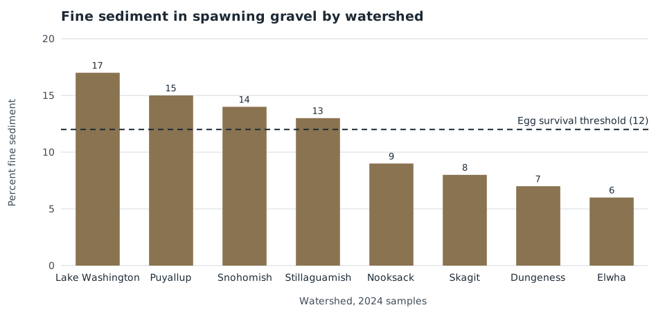
Salmon eggs need clean gravel with cold, oxygen-rich water moving through it. Fine sediment from roads, logging, and eroding banks fills the spaces between stones and smothers eggs before they hatch.
- Fine sediment exceeded 12 percent, the level linked to lower egg survival, at 9 of the 24 sampled sites.
- Sites downstream of dense forest road networks held the most fine sediment. The Elwha, where the dams came out and the channel is rebuilding, held the least.
- Results from 2018 to 2024 show no clear trend across the region.
Data Source: Spawning gravel sediment samples compiled by the Northwest Indian Fisheries Commission
Methods
At each site, freeze cores or McNeil samples are taken from riffle crests used for spawning. Samples are dried and sieved, and the share of material finer than 0.85 millimeters is reported by weight.
Critical Definitions
- Fine sediment: particles smaller than 0.85 millimeters.
- Egg survival threshold: 12 percent fine sediment by weight, above which egg-to-fry survival drops in published field studies.
Fine sediment is highest downstream of dense forest road networks and recently logged steep slopes, and lowest where headwaters are protected. Year-to-year changes follow winter storms more closely than land use, which is why the regional trend is flat.
Causes for Change
Road maintenance and abandonment under forest practices rules reduce sediment delivery over time. Large storms and landslides raise fine sediment for one to three years.
References
Jensen, D. W., E. A. Steel, A. H. Fullerton, and G. R. Pess. 2009. Impact of fine sediment on egg-to-fry survival of Pacific salmon: a meta-analysis of published studies. Reviews in Fisheries Science 17: 348 to 359.
- Spawning gravel sediment samples, 2018 to 2024 (Northwest Indian Fisheries Commission)
- Forest road sediment delivery inventory (Washington State Department of Natural Resources)
Report the median for each watershed with the number of sites sampled. Do not compare watersheds sampled with different methods.
Watershed: Lake Washington, Puyallup, Snohomish, Stillaguamish, Nooksack, Skagit, Dungeness, Elwha