Floodplain function in large and small river systems
- Ecosystem Recovery Goal
- Functioning Habitat
- Vital Sign
- Streams and Floodplains
- Indicator
- Floodplain function in large and small river systems
- Indicator Type
- Vital Sign Indicator
 Salmon Habitat Indicator
- Measurement Unit
- Acre (acres)
- Indicator Trend / Target Status
-

- Target
- No targets are currently set for this indicator.
- Vital Sign Indicator Reporter
- Kenna Kuhn
kenna.kuhn@psp.wa.gov
Puget Sound Partnership - Contributing Partners
- Last Updated
- 09/11/2023
This indicator measures the amount (acres and percent) of floodplain area in functional condition in Puget Sound’s 17 major rivers. Floodplain function is assessed at a regional scale using river connectivity and land use and cover. Areas that have natural land cover and unrestricted river flow are expected to be the most functional and provide the most ecosystem services. Floodplain function is impaired in areas with non-natural land cover or restricted river flow due to constraints or barriers (for example, roads, railroads, and levees).
Floodplains are an important part of the Puget Sound landscape, particularly in the lowlands along large rivers. They are used by people for cities, farms, and transportation. Floodplains provide critical habitat for fish and wildlife, which in turn play a role in human wellbeing, meeting economic, cultural, and recreational needs.
During floods, a wide, connected floodplain allows the river to move and reduces damage to nearby areas by absorbing stormwater and routing water through river corridors while also holding some water to recharge groundwater reserves.
- Puget Sound’s 17 major rivers include more than 440,000 acres of floodplain. Over half (55 percent) of the region’s floodplain area is found in three of the 17 major rivers: Skagit, Snohomish, and Nooksack Rivers.
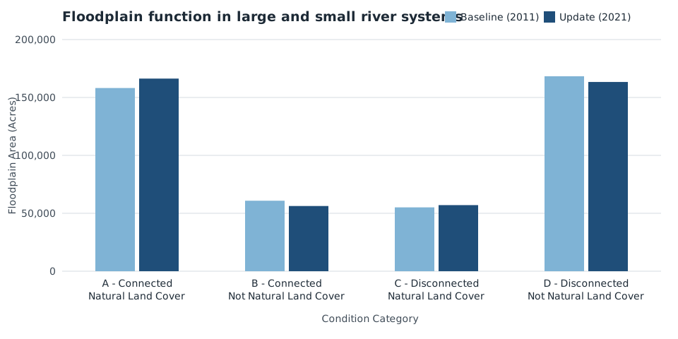
- Across the region, 38 percent (166,294 acres) of the total floodplain area is highly functional (Category A - Connected Natural Land Cover). The remaining 62 percent has reduced floodplain function. This includes 163,374 acres (37 percent of the total floodplain area) where the floodplain is disconnected and classified as developed, cultivated, or other non-natural land cover (Category D - Disconnected Not Natural Land Cover).
- A comparison of floodplain conditions between 2011 and circa 2021, showed the greatest change occurred in Category A (connected natural land cover), with an increase of 8,134 acres. This includes changes in connectivity, land cover, or both. The total area of Category D (disconnected non-natural land cover) declined by 4,925 acres.
- Connected floodplain area [including natural (Category A) and non-natural land cover (Category B)] increased by 3,567 acres since the 2011 assessment. While this points to improving progress in floodplain function, the change in connectivity affects less than 1 percent of the total floodplain area and extensive portions of historical habitat remain lost or degraded across Puget Sound.
- Changes in connectivity between the two time periods largely reflect reconnection projects, including areas associated with the Nisqually Delta Restoration, Dungeness River Reconnection, and Smith Island Estuarine Restoration in the Snohomish River.
Monitoring Program: The Puget Sound Partnership and its partners are responsible for developing, maintaining, and updating these data in coordination with Lead Entities.
Data Source: Floodplains Conditions Assessment (Environmental Science Associates and Puget Sound Partnership 2023)
This indicator describes floodplain function in Puget Sound’s 17 major river watersheds based on river connectivity and categories of land use and land cover. We assessed floodplain conditions at two time periods: a 2011 baseline and a circa 2021 update. The update allows for a more recent assessment of floodplain status and supports the analysis of trends in Puget Sound floodplain function.
Importance to Salmon
Connected floodplains hold side channels and wetlands where juvenile salmon shelter from high winter flows and grow quickly.